Translation help needed!
Printed From: History Community ~ All Empires
Category: Scholarly Pursuits
Forum Name: Linguistics
Forum Discription: Discuss linguistics: the study of languages
URL: http://www.allempires.com/forum/forum_posts.asp?TID=28852
Printed Date: 18-May-2024 at 05:39
Software Version: Web Wiz Forums 9.56a - http://www.webwizforums.com
Topic: Translation help needed!
Posted By: opuslola
Subject: Translation help needed!
Date Posted: 17-Nov-2010 at 15:00
|
This same topic is also posted in the maps section!
If you could take the time, could one of you who is somewhat of a linguist, please look at it, and do some translation from it? Here is the map in question; http://upload.wikimedia.org/wikipedia/commons/d/d3/TabulaRogeriana.jpg Especially these few lines; The below is taken from the Maps section; Referencing the above Map, could someone pleast give me a translation of the following places found on the map? "bahr nilas" and "bahr al hozar", as well as "min al bahr al sami" I would have thought by now, that someone with the linguistic abilities far beyond my on limited ability, might well have explored the map! But it seems that has not happened! So, I will report to you that if either of the above words can be translated to "River Nile" or "Black Sea", or its Latin cognates, then there exists a real problem with the map! It would then seem to indicate that their was not a "river" channel existing between the Sea of Mamara (Marmara Denizi) and the Black Sea! If it is true that the respected scholar who reportedly made the above map, acutally knew his geography, then this omission is insulting to his memory, or perhaps actually portrayed the situation of his times? Also, via looking closely at the map, can the word "bahr" translate as both "Sea" and "river?" Thanks for your help! ------------- http://www.quotationspage.com/subjects/history/ |
Replies:
Posted By: opuslola
Date Posted: 17-Nov-2010 at 22:28
|
Sorry I wanted to keep this on the first page so this post does so!
Help needed! See above! ------------- http://www.quotationspage.com/subjects/history/ |
Posted By: opuslola
Date Posted: 18-Nov-2010 at 17:30
|
Are there no posters here that can translate the map, and my questions above?
Can you Cyrus, or you balochii? Sorry if I mispelled your name! How about you bai_ulgen? ------------- http://www.quotationspage.com/subjects/history/ |
Posted By: Cyrus Shahmiri
Date Posted: 18-Nov-2010 at 18:40
Bahr is an Arabic word which means "Sea", "Hozar" is clearly the same "Khazar", we Iranian usually call the Caspian sea with this name, it is difficult to read other words, this is the correct view of the map:
 ------------- 
|
Posted By: Cyrus Shahmiri
Date Posted: 18-Nov-2010 at 18:56
|
The name of "Nilas" for the "Black Sea" is strange for me, maybe that is just a mistake, as far as I know Arabs have called this sea as "Asvad" (Black), "Bontosh" (Pontos), "Rus", "Kurz/Kurzian" and "Trabzon". -------------
|
Posted By: opuslola
Date Posted: 18-Nov-2010 at 19:08
|
Yes placed with North to the top, in the modern manner!
But, are you able to find Istanbul/Constantinople upon it? It seems to resemble Ptolemy's map to a great extent! India, if there is really an India on the map, seems to not yet be complete, that is there seems to be an island that has yet to collide with the continent and create the mountains! I have seen this in other maps of this era! Can you find Rome? Or any other of the great cities of the past, such as Damascus, Babylon, Mecca/Makka?, Jerusalem, etc.? If not, just why would a Islamist like the creator of this map, excluded these holy places? If you have the ability, please try to maximize the size of the map so you might well be able to read the words? In the map above do we see the Black Sea named? The Caspian Sea seems much larger and further away from what shoud be the Black Sea than normal? Since at one time they are thought to be connected! You also, for some reason failed to translate the words "bahr nilas!", why? Do these words have no meaning for you? How about "min al bahr al sami"? Does this also mean nothing to you? Note, the above words were all found by me on the map! Why do you suffer not to find them? Is it the lack of modern equipment? But, thanks anyway! Opps! I missed one of your posts concerning Nilus! Could it not mean the "NILE?" as in the River NILE? ------------- http://www.quotationspage.com/subjects/history/ |
Posted By: opuslola
Date Posted: 18-Nov-2010 at 19:12
|
Dear Cyrus why do you think that the only man made edifice shown on the map, to my eyes at least, only show what appears to be the Lighthouse at Alexandria?
Regards, ------------- http://www.quotationspage.com/subjects/history/ |
Posted By: opuslola
Date Posted: 17-Mar-2011 at 15:05
|
Again, can anyone else on this site translate the words, and make sense of the map?
Regards, Ron ------------- http://www.quotationspage.com/subjects/history/ |
Posted By: opuslola
Date Posted: 28-Jul-2011 at 14:16
|
Since we now have many new members, perhaps one of you can answer my questions above;
Thus; Again, can anyone else on this site translate the words, and make sense of the map? Regards, ------------- http://www.quotationspage.com/subjects/history/ |
Posted By: opuslola
Date Posted: 08-Dec-2013 at 22:27
|
Can anyone, now on this site contribute a good translation? It seems
that for years no scholar has responded to my quest! Just what could be the problem? Certainly some of you are way more literate than am I? So, just where are the scholarly responses? Ron ------------- http://www.quotationspage.com/subjects/history/ |
Posted By: TheAlaniDragonRising
Date Posted: 08-Dec-2013 at 23:23
|
The Black Sea could have been known as bahr nilas, because from time to time it has been known to freeze. ------------- What a handsome figure of a dragon. No wonder I fall madly in love with the Alani Dragon now, the avatar, it's a gorgeous dragon picture. |
Posted By: TheAlaniDragonRising
Date Posted: 08-Dec-2013 at 23:51
|
As the map is upside down, couldn't min al bahr al sami be something like the Aegean? ------------- What a handsome figure of a dragon. No wonder I fall madly in love with the Alani Dragon now, the avatar, it's a gorgeous dragon picture. |
Posted By: Ollios
Date Posted: 09-Dec-2013 at 00:42
I can't read the city names without one single name Heraklia which is Heraclea in this map ------------- Ellerin Kabe'si var, Benim Kabem İnsandır |
Posted By: yomud
Date Posted: 10-Dec-2013 at 04:27
|
well i cant see any map except ollios's map i will be glad the help you guys if i could see the map
------------- yomud are free people |
Posted By: opuslola
Date Posted: 11-Dec-2013 at 20:42
|
Yomud, here is the question and the map address.
http://upload.wikimedia.org/wikipedia/commons/d/d3/TabulaRogeriana.jpg Especially these few lines; The below is taken from the Maps section; Referencing the above Map, could someone pleast give me a translation of the following places found on the map? "bahr nilas" and "bahr al hozar", as well as "min al bahr al sami" I would have thought by now, that someone with the linguistic abilities far beyond my on limited ability, might well have explored the map! But it seems that has not happened! So, I will report to you that if either of the above words can be translated to "River Nile" or "Black Sea", or its Latin cognates, then there exists a real problem with the map! It would then seem to indicate that their was not a "river" channel existing between the Sea of Mamara (Marmara Denizi) and the Black Sea! If it is true that the respected scholar who reportedly made the above map, actually knew his geography, then this omission is insulting to his memory, or perhaps actually portrayed the situation of his times? Also, via looking closely at the map, can the word "bahr" translate as both "Sea" and "river?" Thanks for your help! Ron ------------- http://www.quotationspage.com/subjects/history/ |
Posted By: Ollios
Date Posted: 12-Dec-2013 at 01:42
Bahr Nilas =Black Sea Bahr al Hozar =Caspian Min al Bahr al Sami = Aegean this is clear as some friends told before. Word bahr (Arabic) means "something which is relevant with sea" according to Turkish dictinory English people use the term Caspian Sea but Turks use word Hazar like similar with Hozar. It comes from Khazars
??? I don't understand the problem 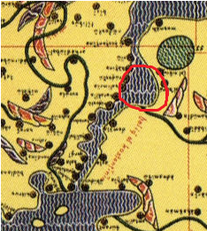 Here is Marmara Sea (I turned the map) and there are two channals. Of course, Strait of Istanbul is very shorter then Dardanelles Marmara water system is prety looking like same in also this map  ------------- Ellerin Kabe'si var, Benim Kabem İnsandır |
Posted By: Ollios
Date Posted: 12-Dec-2013 at 14:37
Can you read the black letters ??? 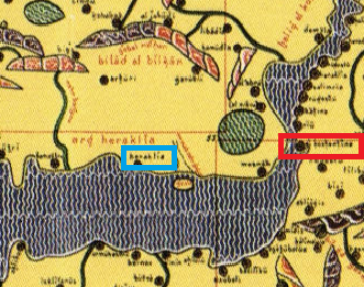 Blue is Heraklia Red is Constantinopole (I think) BTW "Bahriyeli" means sailor soldier in Turkish ------------- Ellerin Kabe'si var, Benim Kabem İnsandır |
Posted By: opuslola
Date Posted: 12-Dec-2013 at 20:37
|
So, Ollios, thanks for the translations! Since I am unable with my limited abilities to expand the examples given here, I must ask you if you see any abnormal names or mentions?
Regards, Ron ------------- http://www.quotationspage.com/subjects/history/ |
Posted By: Ollios
Date Posted: 13-Dec-2013 at 13:23
 Al Jazira Azerbaijan Armenia Three lakes in Armenia-Turkey-Iran but you have to turn the map   Green city could be Diyarbakır-Amed-Amid I can also read word Russia(Rüsia in the map) and Denmark (it is very large in the map) ------------- Ellerin Kabe'si var, Benim Kabem İnsandır |
Posted By: opuslola
Date Posted: 13-Dec-2013 at 18:19
But Ollios, Istanbul cannot be where you circled it in RED! I am assuming that the Black Sea is at the bottom of the map? Thus Constantinople would be at the beginning of the water connection (on the left side) rather than at the end of it on the right side. Is the large green area a lake? Certainly there exists no great lakes anywhere near this area today. Is Heraklia located on the Black Sea or the Sea of Marmara? Or is it located on the Aegean? Is Mt. Beykos listed anywhere on the map? Here is one; http://en.wikipedia.org/wiki/File:Heraclea-Pontica.png But it cannot be the one you mentioned/ boxed in. But the map does not compute as configured. Perhaps this is it? http://en.wikipedia.org/wiki/Perinthus Regards, Ron ------------- http://www.quotationspage.com/subjects/history/ |
Posted By: Ollios
Date Posted: 13-Dec-2013 at 20:38
Yes, Black Sea is bottom. Right side is True. It is Thrace. There were many cities on the north side (Thrace) of Marmara sea and also there were many cities between Marmara-Aegean strait but not big cities at north without Constantinople. Is there any other long name in that region? and it looks also Kostantino, but you are right it looks like İstanbul has coast near the Blacksea instead of Marmara, but it is really tiny mistake near Greece, Denmark and Italy shapes http://www.google.com.tr/url?sa=i&source=images&cd=&docid=nBL6F9HF23xtvM&tbnid=avTt3sI_SbkNrM:&ved=0CAgQjRw&url=http%3A%2F%2Fwww.thracian.info%2Fthrace_maps.htm&ei=s6urUsu4IrDT7AbN3IEw&psig=AFQjCNHWkhq0960WxYzg93YqMkSmcs64uA&ust=1387068723619016"> 
There are three large lakes near the Marmara. but I think this is the one which is in the map. Nicae/İznik Lake. There aren't any great Medieval cities near other two of them  
Accually there is no great mt near the İstanbul. The highest point of the city is 500m
Yes, That Heraclea. Why it can't be? ------------- Ellerin Kabe'si var, Benim Kabem İnsandır |
Posted By: opuslola
Date Posted: 13-Dec-2013 at 23:38
|
Well! It is well to the East of the connection of Europe to Asia, and located on the Black Sea!
Look Ollios! You need to look at some real time maps of the straights that connect the Aegean Sea to the Black Sea! Things just do not fit in your reports. Is there any way to post the entire site in an enlarged form, segment by segment, whereby anyone, including me, can follow the entirety of the map, part by part? By the way Mt. Beykos is the highest point on the narrow "river" that runs from Constantinople North to the Black Sea. Regards, Ron Regards, Ron ------------- http://www.quotationspage.com/subjects/history/ |
Posted By: Ollios
Date Posted: 14-Dec-2013 at 08:49
Turkey is 3 times bigger than UK so I can't know every things(I am not the god) but I was born in a town which is located in south side of Marmara and I am living İstanbul which is located in north side of Marmara, so I mean that I have self-confidence about this subject
Can you be more clear, which things don't fit?
As I said before, there is no mountains in İstanbul. But North Side of the Bosphorus has many hills which is near the sea  as Joshua Hill in Beykoz(a name of the district , probably came from your Mt.) which is ancient pagan place for Posidon/Zeus, Yoros castle is also close place  but these are really low places so why they should be in world map? ----------------------------------------------------------------------------------------------------------  real situation 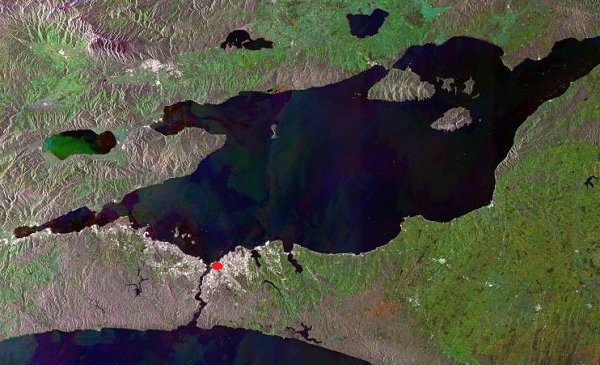 your map (red point is historical Istanbul, inside the city walls)  Look at how narrow is the Bosphorus in this historical map ------------- Ellerin Kabe'si var, Benim Kabem İnsandır |
Posted By: opuslola
Date Posted: 14-Dec-2013 at 15:17
|
Ollios! Thanks for the above work, I merely think we are just having a problem communicating in English.
But, here is an inter-active reproduction of the ancient map. Here you can ZOOM up close and easily read the names of the cities and towns lining the Bosporus. Istambol can be easily seen as can Heraklia! Maybe you can learn something and as a result so can I? SEE; http://zoom.it/wzBY During my inspection of this map, I have only discovered three objects that represent man-made structures. One is the Lighthouse at Alexandria, Egypt, and the other two are located way to the East, ant the map intersection of VII and III and IV. One looks like a defensive tower, and the other looks like a gigantic circular wheel with gear teeth, perhaps a great defensive wall? They are located near one another. I find the lack of notable structures shown on the map as strange. Regards, Ron ------------- http://www.quotationspage.com/subjects/history/ |
Posted By: opuslola
Date Posted: 14-Dec-2013 at 20:28
|
Maybe this will reveal the other two manmade structures?
http://zoom.it/wzBY Nope, but they exist to the corner of the map, going south east. Ron ------------- http://www.quotationspage.com/subjects/history/ |
Posted By: Ollios
Date Posted: 15-Dec-2013 at 03:10
Probably, my english skill isn't as good as my geography
My objection is true according to your map, how can you find this interactive map? Well done  Here is my results and names are coming from this order: English-Turkish-Map Rome - Roma - Ruma  London - Londra - Lond?  Jeddah - Cidde - Gidda Makkah - Mekke - Mekka  Mosul - Musul - Al Mosul Amed - Amed(normaly Diyarbakır) - Amid Nusaybin - Nusaybin - Nisibin Rivers Euphrates - Fırat - Al Frat Tigris - Dicle - Al Digla 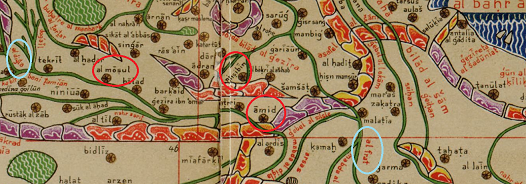 Athens - Atina - Atin 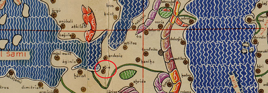 Red Cyprus - Kıbrıs - Kibros Nicosia - Lefkoşe - Lafkisia Kyrneia - Girne - Kornebia Blue - Ancient Kilikia Antioch - Antakya - Antakiu Alexandrette - İskenderun - İskenderuna Adana - Adana - Adana Tarsus - Tarsus - Tarsus Antalya - Antalya - Antalia  Konstantinople - İstanbul - Al Konstantina Nicea - İznik - Al Nikiu we have been talked about Heraklia in Blacksea the other cities Selymbria - Silivri - Salimra Heraclea (or Perinthos) - Marmara Ereğlisi - Heraklia Rodosto - Tekirdağ - Rudostu and Banados ancient city which is actually too close to Tekirdağ. Now it is know with Barbaros neighbourhood of Tekirdağ, its old names are Banados or Parnados  so is there any question or any city where you ask me to look? ------------- Ellerin Kabe'si var, Benim Kabem İnsandır |
Posted By: opuslola
Date Posted: 16-Dec-2013 at 16:29
|
I ask you to look as any good historian should look! Look for things that are correct, and for anything that is incorrect. Be inquisitive, just how many names are different from what you thought they would be, etc.! Use other maps to see if things have changed a lot.
Check out the Far East, where I found two more structures with names I cannot recognize. It looks like there are numerous places named Herakila/Heraclea, etc.! Why? By the way, you wrote these words; " Joshua Hill in Beykoz(a name of the districtBig smile, probably came from your Mt.) which is ancient pagan place for Posidon/Zeus, Yoros castle is also close place." Just what do you personally know about "Joshua Hill?" in Beykoz? Do you know some people call it "Jesus' Hill?", after all the real name of JEsus was Joshua? What do you know of the great grave there? Etc. By the way, I have been to Istanbul one time, via a cruise ship, and loved it. Regards, Ron ------------- http://www.quotationspage.com/subjects/history/ |
Posted By: Ollios
Date Posted: 16-Dec-2013 at 17:18
I have one long shot from this map, there is tower on the mountains which is located on east side of some lakes. But still I can't read it http://upload.wikimedia.org/wikipedia/commons/9/95/Fra_Mauro_World_Map,_c.1450.jpg - http://upload.wikimedia.org/wikipedia/commons/9/95/Fra_Mauro_World_Map,_c.1450.jpg
There are many Heraklia between Greek colonies, this is not odd
I have been visited once, because of my grandmom, the place has been holy since ancient Greece  . There is the Tomb of Saint Joshua on the hill. According to legends, he was really, really and really tall . There is the Tomb of Saint Joshua on the hill. According to legends, he was really, really and really tall   ------------- Ellerin Kabe'si var, Benim Kabem İnsandır |
Posted By: opuslola
Date Posted: 16-Dec-2013 at 20:21
|
Yes, that is the tomb and the place!
Thanks for the great photo! Regards, Ron ------------- http://www.quotationspage.com/subjects/history/ |
Posted By: opuslola
Date Posted: 16-Dec-2013 at 23:25
What a great map of the world ca. 1450? Just where did you find this great map Ollios? But, of course neither of us can read one word of it! Laugh! But, perhaps there exist some persons with a better knowledge of languages, such as our own Cyrus, who might be able to help both of us decipher both of these great maps? So how about it Cyrus? http://upload.wikimedia.org/wikipedia/commons/9/95/Fra_Mauro_World_Map,_c.1450.jpg Regards, Ron Ron ------------- http://www.quotationspage.com/subjects/history/ |
Posted By: opuslola
Date Posted: 17-Dec-2013 at 16:45
|
Ollios! From both maps, there are a few things that I cannot explain. First, there seems to be no representation of the Great Wall of China or any pyramids either in Egypt or China, where there exists hundreds.
The question is WHY? There are only two reasons for such a lack of mention. Either the authors of these maps had no knowledge of them, or perhaps, neither existed when the maps were made!! What is your opinion? Or what is the opinion of any other of our esteemed members, such as Cyrus? One must notice that in the last map example, the Far East is better illustrated than the West! Again, why? Regards, Ron ------------- http://www.quotationspage.com/subjects/history/ |
Posted By: opuslola
Date Posted: 09-Jan-2014 at 22:20
|
Again the same question arises! Just why were these greatest structures of our race/'humanism, are not ever mentioned or even listed within the adventures of one of our greatest adventurous historians?
Just a question that needs more investigation? Regards, Ron ------------- http://www.quotationspage.com/subjects/history/ |
Posted By: yomud
Date Posted: 28-Jan-2014 at 15:52
|
there is 2 very big island in caspian sea near turkmenistan shore which dose not exist !
------------- yomud are free people |
Posted By: mijhn
Date Posted: 24-Jul-2016 at 00:31
|
There is a high resolution copy of the original book at French National Library.
You can zoom in and see all titles on the map: http://i.imgur.com/oJniw9N.jpg The original is in Arabic, so what we see on Wikipedia image is some sort of transliteration made from the original. The page that shows bahr al hazar is here: http://gallica.bnf.fr/ark:/12148/btv1b6000547t/f547.item.r=.langEN.zoom |
Posted By: Aeoli
Date Posted: 24-Jul-2016 at 14:54
Yomud wasn't here but There were some islands in all ancient maps http://previews.123rf.com/images/sergeyussr/sergeyussr1303/sergeyussr130300152/18369319-Caspian-Sea-old-map-Persia-Arabia-Turkey-Iran-Iraq-Stock-Photo.jpg - http://previews.123rf.com/images/sergeyussr/sergeyussr1303/sergeyussr130300152/18369319-Caspian-Sea-old-map-Persia-Arabia-Turkey-Iran-Iraq-Stock-Photo.jpg
|
Posted By: Aeoli
Date Posted: 24-Jul-2016 at 15:12
Yomud was not here but, All ancient maps show islands near Turkmenistan http://previews.123rf.com/images/sergeyussr/sergeyussr1303/sergeyussr130300152/18369319-Caspian-Sea-old-map-Persia-Arabia-Turkey-Iran-Iraq-Stock-Photo.jpg - http://previews.123rf.com/images/sergeyussr/sergeyussr1303/sergeyussr130300152/18369319-Caspian-Sea-old-map-Persia-Arabia-Turkey-Iran-Iraq-Stock-Photo.jpg
|